https://en.wikipedia.org/wiki/Ringfort
https://www.facebook.com/caherconnell/
http://www.burrengeopark.ie/wp-content/uploads/2014/08/Types_of_the_Ring-Forts_and_Similar_Structure_Quinn.pdf
http://www.clarelibrary.ie/eolas/coclare/archaeology/cashels.htm
http://www.clarelibrary.ie/eolas/coclare/archaeology/images/statistical_analysis_ringfort_loop_head.pdf
These were the sources I used in order to conduct my research on the relation of the landscape of County Clare and Ring forts. If you are interested in further reading please visit these sites!
Monday, December 7, 2015
Sunday, December 6, 2015
The Cashel and the Landscape
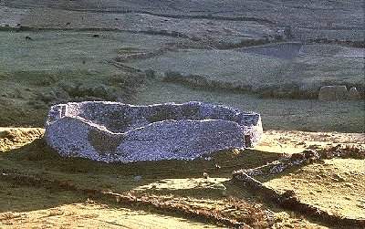
The landscape of county Clare, especially near the Burren, is racked with cashels. Cashels are built on high ground and strategically placed to observe potential danger and watch over the family's land. As you can see in the video above at the Caherconnell stone fort, it is elevated compared to the rest of the land. The inhabitants could have clearly seen their sheep grazing and watch for potential intruders. Often, stone fort inhabitants had relationships with neighboring stone fort families and would assist them in times of need, and the forts were built so that you had clear lines of site to neighboring forts. These forts were hot spots for trade and linked to wealthy inhabitants. At the Caherconnell fort, high status items such as gold, sliver, and bronze tokens, pendants, and coins have been found. Not only are ring forts a part of the cultural and functional landscape of County Clare, Ireland, but they also represent a huge part of the symbolic landscape. For many Irish people, these ring forts are a symbol of Irish pride.
Wednesday, December 2, 2015
Map of Important sections of County Clare
This is a map of the important sections in County Clare in relation to my field work. The blue polygon shows the Burren section of County Clare. If you look at my previous post, you will see a direct correlation between the Burren and the frequency of cashels. The people were using the environment to their advantage while building ring forts. I have also included pictures and videos of the site and lines of known trade going into the site based on the artifacts found during excavation.
Frequency of Cashels in County Clare
County Clare is full of many cashels such as the site I worked at this past summer, Caherconnell. This map from the library of County Clare shows all of the known cashel sites within the county. The occurrence of cashels directly correlates with the region of limestone known as the Burren.
Geography of County Clare
Although ring forts are prevalent around all of Ireland, I chose to focus on the county I did my field research in. County Clare, Ireland is on the West coast of Ireland and is famous for its rocky landscape called the "Burren" meaning "great rock" in Irish Gaelic. This landscape is very different from the rest of Ireland's lush green hills and valleys. The Burren is made of limestone and was formed as a part of the sea 350 million years ago. One of the major theories as to why cashels are more prevalent in County Clare is because of the abundance of rock in the landscape.
What is a Ring Fort?

To understand the importance of ring forts on the landscape of County Clare, Ireland, we must first understand what a ring fort is. A ring fort is a circular fortified settlement that was constructed during the Early Middle ages to the year 1000 AD and continued to be inhabited until as late as the 16th century. There are two different types of ring forts : a rath and a cashel.
Subscribe to:
Comments (Atom)


